The global Urban Underground Utility Mapping Market size was valued at USD 6.31 billion in 2026 and is projected to expand at a compound annual growth rate (CAGR) of 8.5% during the forecast period, reaching a value of USD 10.69 billion by 2033.
MARKET SIZE AND SHARE
The global Urban Underground Utility Mapping Market share is led by electromagnetic induction and ground-penetrating radar technologies. North America holds the largest revenue share, exceeding 35%. Europe follows with strong investments in aging infrastructure replacement, while the Asia-Pacific region shows the fastest compound annual growth rate. Key players include Hexagon, Emerson, GSSI, and US Radar. Emerging LiDAR and acoustic sensing technologies are steadily gaining market share.
Utility mapping services represent the largest segment by share. Equipment sales maintain steady growth, supported by municipal procurement contracts. Public sector investments account for nearly 60% of the total share, while private construction firms form the fastest-growing end-user segment. Mergers and acquisitions among leading providers continue to reshape the competitive landscape. In addition, startups focused on AI-based data interpretation are gaining traction. Improvements in utility localization accuracy continue to drive overall market expansion during the forecast period.
INDUSTRY OVERVIEW AND STRATEGY
The Urban Underground Utility Mapping Market encompasses technologies for locating buried electrical, gas, water, and telecommunication infrastructure. Industry strategy increasingly emphasizes integrating GIS with real-time sensor data. Non-destructive excavation prevention remains the primary value proposition. Key application areas include pre-construction surveys and asset management. Industry players are developing multi-sensor platforms combining radar, electromagnetic, and acoustic technologies. Strategic partnerships with utility owners enable proprietary data access. Standardization initiatives aim to improve data interoperability. The competitive landscape features both established instrumentation manufacturers and specialized service providers.
Leading market participants pursue differentiation through cloud-based data visualization platforms. Strategy prioritizes artificial intelligence for automated feature recognition in complex urban environments. Subscription-based software models represent a significant strategic shift from hardware-only offerings. Training and certification programs build customer loyalty and ensure proper equipment utilization. Industry consolidation through acquisitions targets complementary detection technologies and geographic expansion. Collaborative research initiatives address limitations in deep utility detection. Marketing strategies emphasize damage prevention cost savings. Future strategy centers on developing autonomous mapping solutions for continuous infrastructure monitoring.
REGIONAL TRENDS AND GROWTH
North America and Europe exhibit trends toward mandatory utility mapping regulations driving sustained adoption. Current growth drivers include infrastructure modernization funding and strict excavation safety laws. Asia Pacific trends demonstrate rapid urbanization necessitating comprehensive utility records. Major growth restraint involves high equipment costs limiting penetration in developing regions. Opportunities exist in retrofitting older cities lacking accurate utility maps. Challenges include signal interference in congested urban corridors. Latin American markets show emerging growth trends through PPP infrastructure projects. Middle Eastern investment in new smart cities creates significant mapping opportunities.
Current growth factors include government mandates for subsurface utility engineering prior to construction. Restraints encompass inconsistent regulatory frameworks across jurisdictions. Future growth opportunities arise from climate resilience initiatives requiring utility relocation from flood zones. Technological trends favor drone-mounted and robotic mapping systems. Significant challenge remains accurate detection of non-conductive plastic pipes. Driver includes rising third-party damage costs promoting proactive mapping. Opportunities in Southeast Asia correlate with massive transportation infrastructure development. Future growth trends indicate convergence of BIM and utility mapping data. Restraint involves shortage of qualified geophysicists for complex data interpretation.
URBAN UNDERGROUND UTILITY MAPPING MARKET SEGMENTATION ANALYSIS
BY TYPE:
The market by type is primarily driven by technological accuracy, detection depth, and data reliability. Ground Penetrating Radar (GPR) dominates due to its superior ability to detect non-metallic utilities and provide high-resolution subsurface images. Electromagnetic location methods remain highly adopted for metallic utility detection, especially in gas and power sectors. LiDAR mapping is gaining traction for urban planning and digital twin development, while acoustic detection supports leak detection and pipeline monitoring applications.
Growing urban congestion, infrastructure modernization, and safety regulations significantly boost adoption of advanced detection types. Magnetic field detection is expanding due to its reliability in dense utility networks, while GPS-based mapping ensures high-precision geospatial referencing. The integration of multiple detection technologies improves mapping accuracy, reduces excavation risks, and enhances operational efficiency. Continuous technological innovation, combined with rising infrastructure investments, is accelerating demand for hybrid and advanced mapping systems across metropolitan regions.
BY APPLICATION:
Water and sewer utilities dominate application demand due to aging pipelines, leakage concerns, and increasing urban water stress. Gas utilities exhibit rapid growth owing to strict safety regulations and rising energy distribution infrastructure. Electrical utilities leverage underground mapping for fault detection, maintenance planning, and urban grid optimization. Telecommunication networks significantly contribute due to large-scale fiber optic expansion, 5G rollout, and smart city connectivity requirements.
Stormwater drainage systems and wastewater networks also drive demand due to frequent urban flooding and drainage failures. Rapid urbanization, population density, and infrastructure expansion are intensifying underground network complexity. This necessitates accurate utility mapping for planning, maintenance, and emergency response. Governments and municipal bodies increasingly mandate precise subsurface data before construction approvals, further stimulating application-driven growth in underground utility mapping services.
BY TECHNOLOGY:
2D mapping remains widely used due to cost efficiency and simplicity, particularly in small-scale projects. However, 3D mapping is experiencing rapid adoption due to its superior visualization, depth analysis, and integration with advanced construction planning tools. GIS-based mapping forms the backbone of utility data management, enabling spatial analysis, data layering, and asset lifecycle monitoring. BIM integration enhances infrastructure planning accuracy and supports large-scale urban development initiatives.
Remote sensing and IoT-enabled mapping are emerging technologies reshaping real-time monitoring and predictive maintenance. IoT sensors facilitate continuous underground asset condition monitoring, reducing failure risks. Remote sensing enables wide-area scanning, improving detection speed. Technological convergence is improving data precision, automation, and digital transformation across utility management systems. These advancements are increasingly crucial for smart cities, disaster management, and sustainable infrastructure planning.
BY COMPONENT:
Hardware components such as GPR systems, electromagnetic locators, LiDAR scanners, and GPS receivers dominate market revenue due to high equipment costs. Software platforms are rapidly gaining traction due to rising demand for advanced visualization, data analytics, and digital twin integration. Mapping and visualization software enable better decision-making, infrastructure planning, and maintenance scheduling, driving significant investment across public and private sectors.
Service components including surveying, detection, mapping, consulting, and maintenance play a vital role in project execution. Increasing outsourcing of specialized surveying services and rising regulatory compliance requirements support strong service segment growth. Data processing and visualization tools improve asset management and predictive analysis. The combined demand for integrated hardware-software-service solutions is accelerating market expansion across urban infrastructure development projects globally.
BY OFFERING:
Survey and detection services form the core of market offerings, driven by mandatory underground scanning before excavation. Mapping services are expanding rapidly due to increasing digital documentation and regulatory data archiving mandates. Data analysis services enable predictive maintenance and infrastructure optimization, enhancing operational efficiency and long-term asset planning. Consulting services assist governments and urban planners in infrastructure modernization and smart city implementation strategies.
Maintenance services ensure continuous system reliability and data accuracy, particularly for long-term infrastructure management. Growing infrastructure investments, urban redevelopment projects, and safety mandates are fueling demand across all offering categories. Integrated service models combining detection, mapping, consulting, and maintenance provide comprehensive utility lifecycle solutions. This holistic service approach enhances customer value, operational accuracy, and infrastructure sustainability.
BY DEPLOYMENT MODE:
On-premise deployment remains preferred by government agencies and large utility firms due to data security, regulatory compliance, and control over sensitive infrastructure information. Cloud-based deployment is witnessing accelerated growth owing to scalability, real-time accessibility, cost efficiency, and collaborative project management advantages. Hybrid deployment models are gaining popularity by combining cloud flexibility with on-premise data protection.
Web-based and mobile-based platforms enhance field data collection, operational efficiency, and real-time visualization. Mobile integration allows engineers and surveyors to update data instantly, improving workflow efficiency. Standalone systems remain relevant for isolated projects or regions with limited internet connectivity. Increasing digital transformation, remote collaboration, and cloud computing adoption continue driving deployment innovation across the underground utility mapping ecosystem.
BY END USER:
Government authorities and municipal corporations dominate market demand due to large-scale infrastructure development, smart city projects, and regulatory compliance mandates. Utility companies rely heavily on mapping solutions for network optimization, predictive maintenance, and outage prevention. Construction companies increasingly adopt utility mapping to reduce excavation risks, project delays, and cost overruns. Engineering firms leverage detailed subsurface data for infrastructure design accuracy.
Surveying agencies provide specialized technical expertise, supporting detection and mapping execution. The rising complexity of urban infrastructure, safety regulations, and legal liabilities are driving adoption across all end-user segments. Increasing investments in transportation networks, smart utilities, and sustainable urban development further stimulate market demand. Cross-sector collaboration among government, utilities, and private firms accelerates technological integration and market growth.
BY INDUSTRY VERTICAL:
Construction and infrastructure development industries dominate due to large-scale urban expansion, metro rail projects, highways, and commercial development. The oil and gas sector extensively uses underground mapping for pipeline safety, leak prevention, and regulatory compliance. Power and energy industries depend on mapping solutions for underground cable detection, maintenance planning, and grid modernization initiatives.
Transportation infrastructure such as metros, railways, airports, and highways increasingly require precise subsurface mapping for project safety and execution efficiency. Smart city initiatives integrate underground mapping into digital governance frameworks. Rapid urbanization, infrastructure modernization, and climate-resilient development policies are driving cross-industry adoption. This multi-vertical demand significantly strengthens long-term market expansion prospects.
BY SURVEY METHOD:
Active surveys dominate due to their high accuracy and ability to detect complex underground networks. Passive surveys are widely used for identifying existing electromagnetic signals, offering cost-effective detection solutions. Non-invasive survey methods are rapidly gaining traction due to minimal surface disruption, faster data collection, and enhanced safety compliance. Invasive surveys remain essential for high-precision depth validation and complex subsurface investigations.
Geophysical surveys provide advanced subsurface profiling, while hydrographic surveys support underground drainage and wastewater system mapping. Increasing safety regulations, urban density, and infrastructure complexity necessitate accurate and reliable survey techniques. Technological advancements in non-invasive geophysical tools are transforming data acquisition speed and precision, further enhancing market growth across civil engineering, utilities, and urban planning sectors.
RECENT DEVELOPMENTS
- In Jan 2024: Hexagon AB acquired leading underground mapping software firm to enhance AI-powered utility detection and cloud-based asset management platform capabilities globally.
- In Mar 2024: US Radar launched advanced tri-band GPR system specifically designed for deep urban utility detection in congested subsurface environments with enhanced accuracy.
- In Jun 2024: Emerson partnered with Singapore government to deploy comprehensive underground utility mapping network across entire downtown district using electromagnetic sensors.
- In Sep 2024: GSSI introduced SIR 4000 upgrade featuring machine learning algorithms for automatic plastic pipe identification from complex radar signal data.
- In Nov 2024: SPX Corporation acquired pipeline inspection robotics company to integrate with utility mapping solutions for comprehensive underground infrastructure assessment.
- In Jan 2025: IDS GeoRadar unveiled Stream UP digital GPR array offering real-time 3D utility mapping visualization directly on tablet devices for field crews.
- In Mar 2025: Utility Survey Corp launched nationwide utility mapping data repository platform aggregating records from fifty major US municipalities.
- In May 2025: Vivax-Metrotech released vLoc3-Pro with advanced Bluetooth connectivity and GIS integration for seamless utility map data transfer.
- In Jul 2025: Sensors & Software Inc announced strategic collaboration with EPRI for nuclear plant underground utility mapping standardization protocols.
- In Sep 2025: Leica Geosystems introduced BLK2FLY autonomous flying sensor for aerial-based underground utility detection in restricted access urban areas.
KEY PLAYERS ANALYSIS
- Hexagon AB
- Emerson Electric Co.
- GSSI Inc.
- US Radar Inc.
- IDS GeoRadar Srl
- Sensors & Software Inc.
- Vivax-Metrotech Corp.
- SPX Corporation
- Leica Geosystems AG
- Radiodetection Ltd.
- Pipehawk Plc
- Proceq SA
- MALA Geoscience AB
- Geophysical Survey Systems Inc.
- Sewerin GmbH
- Rohde & Schwarz GmbH
- 3D Radar AS
- Guideline Geo AB
- SSI Energy Inc.
- Utility Survey Corp
Urban Underground Utility Mapping Market Segmentation Analysis
By Type:
- Electromagnetic Location
- Ground Penetrating Radar (GPR)
- LiDAR Mapping
- Acoustic Detection
- Magnetic Field Detection
- GPS-Based Mapping
By Application:
- Water Utilities
- Gas Utilities
- Electrical Utilities
- Telecommunication Networks
- Sewer Systems
- Stormwater Drainage
By Technology:
- 2D Mapping
- 3D Mapping
- GIS-Based Mapping
- BIM Integration
- Remote Sensing
- IoT-Enabled Mapping
By Component:
- Hardware
- Software
- Services
- Data Collection Tools
- Data Processing Tools
- Visualization Platforms
By Offering:
- Survey Services
- Detection Services
- Mapping Services
- Data Analysis Services
- Consulting Services
- Maintenance Services
By Deployment Mode:
- On-Premise
- Cloud-Based
- Hybrid
- Web-Based
- Mobile-Based
- Standalone Systems
By End User:
- Government Authorities
- Municipal Corporations
- Utility Companies
- Construction Companies
- Engineering Firms
- Surveying Agencies
By Industry Vertical:
- Construction
- Infrastructure Development
- Oil & Gas
- Power & Energy
- Transportation
- Smart Cities
By Survey Method:
- Active Survey
- Passive Survey
- Non-Invasive Survey
- Invasive Survey
- Geophysical Survey
- Hydrographic Survey
By Geography:
- North America (USA, Canada, Mexico)
- Europe (UK, Germany, France, Italy, Spain, Rest of Europe)
- Asia-Pacific (China, Japan, Australia, South Korea, India, Rest of Asia-Pacific)
- South America (Brazil, Argentina, Rest of South America)
- Middle East and Africa (GCC Countries, South Africa, Rest of MEA)
Urban Underground Utility Mapping Market: Table of Contents
Introduction
- Market Definition
- Market Scope
- Study Objectives
- Target Audience
- Report Structure
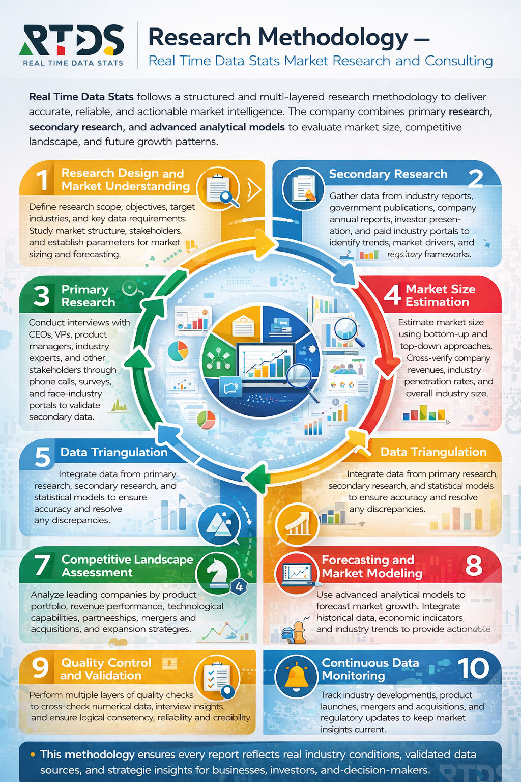
Research Methodology
- Primary Research
- Secondary Research
- Data Collection Techniques
- Data Validation Process
- Market Estimation Methodology
- Forecasting Model
- Assumptions & Limitations
Executive Summary
- Market Overview
- Key Findings
- Market Highlights
- Strategic Recommendations
- Market Overview
- Industry Value Chain Analysis
- Market Ecosystem
Market Dynamics
- Drivers
- Restraints
- Opportunities
- Challenges
Porter’s Five Forces Analysis
- PESTLE Analysis
- Technology Landscape
- Regulatory Framework
- Competitive Landscape Overview
Urban Underground Utility Mapping Market Segmentation Analysis
- By Type
- Electromagnetic Location
- Ground Penetrating Radar (GPR)
- LiDAR Mapping
- Acoustic Detection
- Magnetic Field Detection
- GPS-Based Mapping
- By Application
- Water Utilities
- Gas Utilities
- Electrical Utilities
- Telecommunication Networks
- Sewer Systems
- Stormwater Drainage
- By Technology
- 2D Mapping
- 3D Mapping
- GIS-Based Mapping
- BIM Integration
- Remote Sensing
- IoT-Enabled Mapping
- By Component
- Hardware
- Software
- Services
- Data Collection Tools
- Data Processing Tools
- Visualization Platforms
- By Offering
- Survey Services
- Detection Services
- Mapping Services
- Data Analysis Services
- Consulting Services
- Maintenance Services
- By Deployment Mode
- On-Premise
- Cloud-Based
- Hybrid
- Web-Based
- Mobile-Based
- Standalone Systems
- By End User
- Government Authorities
- Municipal Corporations
- Utility Companies
- Construction Companies
- Engineering Firms
- Surveying Agencies
- By Industry Vertical
- Construction
- Infrastructure Development
- Oil & Gas
- Power & Energy
- Transportation
- Smart Cities
- By Survey Method
- Active Survey
- Passive Survey
- Non-Invasive Survey
- Invasive Survey
- Geophysical Survey
- Hydrographic Survey
Regional Market Analysis
- North America Market Overview
- Europe Market Overview
- Asia Pacific Market Overview
- Latin America Market Overview
- Middle East Market Overview
- Africa Market Overview
Competitive Landscape
- Market Share Analysis
- Company Profiling
- Strategic Initiatives
- Product Portfolio Analysis
- Recent Developments
- Mergers & Acquisitions
- Partnerships & Collaborations
- Innovation & R&D Activities
Investment Analysis
- Funding Trends
- Venture Capital Investments
- Government Initiatives
- Infrastructure Development Projects
- Smart City Projects
Future Outlook
- Market Forecast
- Growth Opportunities
- Emerging Technologies
- Strategic Roadmap
Conclusion
- Market summary
- Key findings
- Strategic insights
Appendix
- Abbreviations
- Data Sources
- Research Methodology Details
- Disclaimer
- About the Publisher
List of Tables
- Table:1: Global Market Size Overview
- Table:2: Market Segmentation by Type
- Table:3: Market Segmentation by Application
- Table:4: Market Segmentation by Technology
- Table:5: Market Segmentation by Component
- Table:6: Market Segmentation by Offering
- Table:7: Market Segmentation by Deployment Mode
- Table:8: Market Segmentation by End User
- Table:9: Market Segmentation by Industry Vertical
- Table:10: Market Segmentation by Survey Method
- Table:11: Regional Market Analysis
- Table:12: Competitive Market Share
- Table:13: Key Company Profiles
- Table:14: Investment Trends Analysis
- Table:15: Market Forecast Summary
List of Figures
- Figure:1: Global Market Overview Diagram
- Figure:2: Research Methodology Framework
- Figure:3: Market Dynamics Analysis
- Figure:4: Value Chain Analysis
- Figure:5: Market Ecosystem Diagram
- Figure:6: Technology Landscape Overview
- Figure:7: Regional Market Share Distribution
- Figure:8: Competitive Landscape Mapping
- Figure:9: Market Segmentation Overview
- Figure:10: Growth Trend Analysis
- Figure:11: Investment Flow Diagram
- Figure:12: Strategic Framework Model
- Figure:13: Market Opportunity Matrix
- Figure:14: Future Outlook Projection
- Figure:15: Industry Roadmap Illustration
Urban Underground Utility Mapping Market Key Factors
Drivers:
- Cities upgrade aging water and gas lines, requiring accurate maps.
- Contractors avoid costly strikes by locating buried cables before digging.
- Governments mandate subsurface surveys to approve new construction permits.
Restraints:
- High equipment costs prevent small firms from purchasing advanced scanners.
- Dense metal grids in old districts confuse traditional electromagnetic locators.
- Unpaved alleys and informal settlements lack any existing as-built records.
Opportunities:
- Engineers combine ground-penetrating radar with AI to interpret messy data.
- Telecom firms map ducts precisely before laying 5G fiber optics.
- Insurers offer lower premiums to utilities that verify underground assets.
Challenges:
- Clay soils and constant rain degrade radar signal penetration depths.
- Multiple operators refuse to share proprietary pipeline coordinates publicly.
- Rapid street repaving seals newly discovered errors before crews correct them.
Urban Underground Utility Mapping Market Key Regional Trends
North America:
- States mandate one-call centers to dispatch mappers before any excavation.
- DOTs scan bridge footings to prevent foundation clashes with old conduits.
- Private equity funds acquire mapping startups to build national dataset libraries.
Europe:
- Historic city centers restrict digging, forcing contractors to map via remote sensors.
- EU directives standardize digital twin formats for cross-border rail projects.
- Municipalities deploy lidar-equipped vans to capture street-level subsurface clues.
Asia Pacific:
- China scans massive new districts pre-emptively before installing smart meters.
- India maps slum electrification routes to thread cables through chaotic lanes.
- Japan uses ultrasonic arrays to locate quake-damaged water pipes without excavation.
Middle East & Africa:
- Gulf megaprojects require full 3D utility models handed over at building handover.
- South Africa traces illegal tapping connections that bleed municipal water supplies.
- UAE tests drone-mounted GPR to map remote desert pipeline corridors swiftly.
South America:
- Brazil maps landslide-prone favelas to reroute exposed gas lines to safety.
- Chile scans port expansion zones to avoid ripping out active fuel hydrants.
- Colombia links cadastral surveys with utility maps to formalize land titles.
Frequently Asked Questions
Key Questions Answered
- What is the size and growth rate of the market industry?
- What are the main drivers influencing market growth trends?
- What are the key challenges and restraints faced by the market?
- What are the emerging trends and opportunities shaping the market?
- Who are the top players, and what strategies drive their success?
- What are the customer demographics and their buying behaviors?
- What are the key market segments, and what is their scope?
- What are the geographical dynamics, and which region dominates?
- What are the market forecasts and projections for the next decade?
- What regulatory factors are critical to consider for market growth?
Why Choose our Company?
- Major facts and stats backing every report we offer.
- Comprehensive analysis tailored to your business needs.
- Accurate insights backed by extensive market research.
- Expert support to address your queries promptly.
- Data-driven strategies for better decision-making.
- In-depth reports with actionable
recommendations. - Reliable statistics from trusted industry
sources. - Customizable reports to suit your specific goals.
- Unmatched quality and precision in market analysis.
- Competitive pricing with premium content delivery.
Share your experience!
We value you feedback. Please take a moment to review your experience with us.