According to insights from Real Time Data Stats, the Urban Flood Prediction Software Market was valued at USD 310 million in 2025. It is expected to grow from USD 350 million in 2026 to USD 730 million by 2033, registering a CAGR of 11.2% during the forecast period (2026–2033).
MARKET SIZE AND SHARE
The global urban flood prediction software market is expanding due to increasing climate-driven flood events and strict government mandates for resilient infrastructure. Market share is concentrated among key technology providers and specialized analytics firms, while competition is intensifying as new entrants use AI and IoT to target niche segments in this high-growth sector.
Market share dynamics continue to evolve, with established engineering software companies holding significant portions, while agile AI startups gain traction. North America and Europe currently hold the largest shares due to advanced adoption and strong funding. However, Asia-Pacific is expected to witness the highest growth rate, shaping future market distribution as investments in smart city initiatives rise globally through 2033.
INDUSTRY OVERVIEW AND STRATEGY
The urban flood prediction software industry integrates hydrology, real-time sensor data, and machine learning to simulate and forecast flood scenarios. It serves municipal governments, disaster management agencies, and insurance companies. The competitive landscape is defined by continuous innovation, where accuracy and lead time of predictions are critical differentiators. Strategic partnerships with city planners and cloud service providers are fundamental for scalability and integration into broader smart city ecosystems.
Core industry strategy revolves around enhancing predictive models with higher-resolution data from satellites and IoT networks. Companies are aggressively pursuing SaaS-based offerings to improve accessibility for mid-sized cities. A key strategic focus is moving from pure prediction to integrated decision-support platforms, offering mitigation planning and asset management tools. This shift creates recurring revenue streams and deeper client engagement, securing long-term market position.
REGIONAL TRENDS AND GROWTH
In North America and Europe, growth is driven by retrofitting legacy infrastructure and strict regulatory frameworks. The Asia-Pacific region is the fastest-growing market, propelled by rapid urbanization, massive government investments in flood control, and increasing vulnerability. Latin America and the Middle East & Africa show emerging potential, driven by new smart city projects and escalating climate awareness, though growth is uneven due to funding variability.
Primary drivers include climate change escalating flood frequency, rising smart city investments, and advances in AI/ML. Key restraints are high implementation costs and data silos across municipalities. Significant opportunities lie in integrating with urban digital twins and offering climate-risk analytics for real estate. Major challenges involve ensuring model accuracy for complex, built environments and navigating the fragmented nature of municipal procurement cycles globally.
URBAN FLOOD PREDICTION SOFTWARE MARKET SEGMENTATION ANALYSIS
BY TYPE:
The By Type segment of the Urban Flood Prediction Software Market is strongly influenced by technological maturity, scalability requirements, and data processing capacity. Cloud-Based Software and Hybrid Software dominate due to flexibility, remote accessibility, and lower infrastructure dependency, while On-Premise Software continues to hold value among security-focused institutions. AI-Driven Prediction Software is expanding rapidly as predictive accuracy and automation become critical, while Real-Time Monitoring Software gains traction from the need for instant alerts and rapid decision-making in high-risk urban zones.
Simulation & Modeling Software plays a dominant role where urban planners and environmental agencies require long-term flood scenario projections and infrastructure planning tools. Growth is also shaped by interoperability with GIS platforms, continuous algorithm upgrades, and user-friendly interfaces. Market dominance factors include processing speed, customization capability, integration with sensor networks, and affordability. Vendors that provide multi-functional platforms combining simulation, AI analytics, and real-time dashboards tend to achieve stronger adoption across municipalities and engineering firms.
BY APPLICATION:
The By Application segment is driven by rising urban flooding incidents, infrastructure vulnerability, and increasing demand for preventive disaster management systems. Municipal Flood Management and Disaster Response Agencies represent leading adoption areas because they require continuous monitoring, early warning alerts, and coordinated emergency planning tools. Urban Planning Authorities are also major contributors as software solutions enable drainage design optimization, zoning analysis, and climate-resilient city development strategies that reduce long-term economic losses and infrastructure damage.
Environmental Monitoring and Insurance Risk Assessment are expanding due to data-driven decision frameworks and risk quantification needs. Infrastructure Protection gains momentum as transportation networks, bridges, and energy facilities demand predictive protection mechanisms. Dominant factors include regulatory compliance, funding availability, cross-department data sharing, and accuracy of rainfall and terrain analytics. Applications that combine visualization dashboards, predictive alerts, and historical data modeling show higher penetration, particularly in regions experiencing frequent climate-induced flooding events and smart-city expansion initiatives.
BY DEPLOYMENT MODE:
The By Deployment Mode segment is shaped by data security priorities, operational cost considerations, and accessibility requirements. Public Cloud solutions dominate among small and mid-sized organizations because of cost efficiency and scalability, whereas Private Cloud is favored by government and defense-linked institutions that prioritize data confidentiality and compliance. Hybrid Deployment is witnessing strong momentum as organizations aim to balance security with scalability while maintaining operational continuity during peak disaster periods.
Edge Deployment and Local Server Deployment grow in importance where low-latency processing and offline functionality are necessary, particularly in flood-prone zones with unstable internet connectivity. Dominant factors include network reliability, cybersecurity frameworks, infrastructure readiness, and maintenance expenses. Deployment flexibility, cross-platform synchronization, and remote accessibility significantly influence purchasing decisions. Vendors offering adaptive deployment models and automated backup systems gain competitive advantage, especially in regions implementing digital governance and large-scale smart infrastructure projects.
BY END USER:
The By End User segment is largely influenced by funding capacity, operational scale, and disaster preparedness mandates. Government Bodies lead the market due to national flood mitigation programs, urban resilience policies, and infrastructure modernization initiatives. Utility Providers and Construction Companies also form strong user bases as they require predictive tools to safeguard water systems, power grids, and large development projects from weather-related disruptions and financial losses.
Private Enterprises and Research Institutions contribute through technological experimentation, climate modeling, and smart infrastructure development. NGOs & Non-Profits expand adoption in humanitarian and environmental conservation efforts where early warning systems protect vulnerable populations. Dominant factors include public-private partnerships, grant availability, digital literacy, and long-term cost savings. End users preferring integrated platforms with analytics, alert mechanisms, and GIS compatibility demonstrate higher retention rates and consistent upgrade cycles.
BY COMPONENT:
The By Component segment is driven by the need for integrated operational efficiency and seamless data flow across platforms. Software Platforms and Data Analytics Tools dominate because they form the functional core of prediction systems, enabling modeling accuracy and automated insights. Visualization Dashboards are equally important as they convert complex datasets into actionable visual intelligence for urban planners, emergency responders, and infrastructure managers during critical decision-making moments.
APIs & Integration Tools and Data Management Modules gain strength due to rising interoperability demands with external databases, weather systems, and IoT networks. Alert & Notification Systems remain vital for real-time responsiveness and public safety communication. Dominant factors include user interface design, processing speed, compatibility with external devices, and cloud synchronization capabilities. Vendors that deliver modular, scalable components with cybersecurity features and automated reporting tools achieve stronger long-term adoption across both public and private sectors.
BY TECHNOLOGY:
The By Technology segment is heavily influenced by innovation speed, algorithm efficiency, and data processing advancements. Artificial Intelligence and Machine Learning are primary growth drivers due to predictive precision, automated pattern recognition, and continuous self-learning capabilities. Geographic Information Systems (GIS) maintain strong dominance because spatial mapping and terrain analysis are foundational for flood modeling and urban drainage assessments across large metropolitan landscapes.
Remote Sensing, Big Data Analytics, and Internet of Things (IoT) collectively strengthen system reliability by delivering real-time environmental inputs and large-scale data correlation. Dominant factors include computing power, data accuracy, system interoperability, and research investments. Technologies that merge AI with IoT sensor networks and GIS mapping provide superior forecasting accuracy, which significantly influences government procurement decisions and infrastructure planning strategies in rapidly urbanizing regions.
BY DATA SOURCE:
The By Data Source segment is shaped by information reliability, real-time availability, and geographic coverage. Satellite Data and Radar Data hold major dominance because they provide large-scale weather visualization and rainfall intensity tracking across urban and coastal regions. Sensor Networks and Weather Stations also play essential roles by delivering localized environmental data, enabling micro-level flood predictions and infrastructure risk evaluations.
Historical Databases and Crowd-Sourced Data contribute to trend analysis and situational awareness, especially during emergency response scenarios. Dominant factors include data accuracy, update frequency, integration compatibility, and storage capacity. Systems capable of merging multiple data streams into unified predictive dashboards experience higher adoption. Continuous improvements in satellite resolution, IoT connectivity, and automated data validation significantly enhance forecasting reliability and decision-making confidence.
BY ORGANIZATION SIZE:
The By Organization Size segment is influenced by budget allocation, technical expertise, and scalability requirements. Large Enterprises and Multinational Corporations dominate due to substantial infrastructure investments, advanced analytics adoption, and multi-city operational needs. Public Sector Units also represent a significant share as national and regional governments invest heavily in climate resilience technologies and public safety frameworks.
Small Enterprises, Medium Enterprises, and Startups demonstrate steady growth driven by cloud-based affordability and subscription models. Dominant factors include financial flexibility, customization needs, workforce skill levels, and digital transformation strategies. Startups often drive innovation through AI-based niche solutions, while larger organizations prioritize integrated platforms with extensive data storage and advanced predictive algorithms, leading to differentiated purchasing behavior across organizational scales.
BY INDUSTRY VERTICAL:
The By Industry Vertical segment is propelled by sector-specific vulnerability to flooding and infrastructure exposure. Transportation and Energy & Utilities dominate because disruptions in roads, railways, and power grids create extensive economic losses, pushing operators toward predictive monitoring systems. Water Management also remains a primary vertical due to direct dependence on hydrological analytics, reservoir monitoring, and drainage optimization tools.
Real Estate, Agriculture, and Telecommunications show rising adoption as climate uncertainty increasingly affects asset value, crop yield stability, and network reliability. Dominant factors include infrastructure density, regulatory mandates, insurance liabilities, and long-term cost prevention benefits. Verticals integrating flood prediction software with asset management systems and emergency communication platforms demonstrate higher resilience levels and sustained investment growth across both developed and emerging urban economies.
RECENT DEVELOPMENTS
- In Jan 2024: Bentley Systems acquired Keynetix, enhancing its geotechnical and water data integration capabilities for more accurate subsurface modeling in flood prediction workflows.
- In Jun 2024: Google Research unveiled a new AI model, HydroNet, significantly improving urban flood forecast lead times by analyzing real-time drainage and weather data.
- In Sep 2024: The UK Environment Agency awarded a multi-year contract to Jacobs and Previsico to deploy a nationwide, real-time surface water flood forecasting and warning system.
- In Feb 2025: Siemens and NVIDIA announced a collaboration to develop digital twin solutions for city infrastructure, featuring high-fidelity flood simulation and scenario planning.
- In May 2025: Innovyze, a subsidiary of Autodesk, launched its next-generation InfoWorks ICM Live, a SaaS platform for real-time urban flood modeling and operational management.
KEY PLAYERS ANALYSIS
- Autodesk Inc. (Innovyze)
- Bentley Systems
- Siemens AG
- DHI Group
- ESRI
- IBM Corporation
- Google (Alphabet Inc.)
- Microsoft Corporation
- Jacobs Engineering Group Inc.
- AtkinsRéalis
- AECOM
- KISTERS AG
- Previsico
- Upstream Tech (a part of Planet Labs)
- Fathom Global
- RMSI
- JBA Consulting
- Vexcel Data Program (Microsoft)
- Trimble Inc.
- SensorFlow
Urban Flood Prediction Software Market Segmentation Analysis
By Type:
- Cloud-Based Software
- On-Premise Software
- Hybrid Software
- AI-Driven Prediction Software
- Real-Time Monitoring Software
- Simulation & Modeling Software
By Application:
- Municipal Flood Management
- Disaster Response Agencies
- Urban Planning Authorities
- Environmental Monitoring
- Insurance Risk Assessment
- Infrastructure Protection
By Deployment Mode:
- Public Cloud
- Private Cloud
- Community Cloud
- Hybrid Deployment
- Edge Deployment
- Local Server Deployment
By End User:
- Government Bodies
- Private Enterprises
- Research Institutions
- NGOs & Non-Profits
- Construction Companies
- Utility Providers
By Component:
- Software Platforms
- Data Analytics Tools
- Visualization Dashboards
- APIs & Integration Tools
- Alert & Notification Systems
- Data Management Modules
By Technology:
- Artificial Intelligence
- Machine Learning
- Geographic Information Systems (GIS)
- Remote Sensing
- Big Data Analytics
- Internet of Things (IoT)
By Data Source:
- Satellite Data
- Radar Data
- Sensor Networks
- Weather Stations
- Historical Databases
- Crowd-Sourced Data
By Organization Size:
- Small Enterprises
- Medium Enterprises
- Large Enterprises
- Startups
- Public Sector Units
- Multinational Corporations
By Industry Vertical:
- Transportation
- Energy & Utilities
- Real Estate
- Agriculture
- Telecommunications
- Water Management
By Geography:
- North America (USA, Canada, Mexico)
- Europe (UK, Germany, France, Italy, Spain, Rest of Europe)
- Asia-Pacific (China, Japan, Australia, South Korea, India, Rest of Asia-Pacific)
- South America (Brazil, Argentina, Rest of South America)
- Middle East and Africa (GCC Countries, South Africa, Rest of MEA)
Urban Flood Prediction Software Market: Table of Contents
Executive Summary
- Market Snapshot
- Key Findings
- Analyst Insights
- Winning Strategies
- Future Highlights
Introduction
- Market Definition
- Market Scope
- Market Segmentation Overview
- Stakeholder Analysis
- Study Objectives
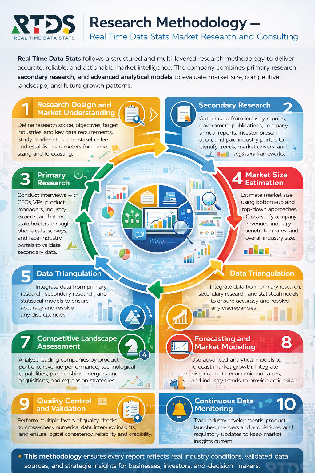
Research Methodology
- Primary Research
- Secondary Research
- Data Triangulation
- Forecasting Model
- Assumptions & Limitations
Market Dynamics
- Drivers
- Restraints
- Opportunities
- Challenges
Regulatory & Policy Framework
- Environmental Regulations
- Data Privacy Laws
- Government Initiatives
- Compliance Standards
Technology Landscape
- Artificial Intelligence
- Machine Learning
- GIS Integration
- IoT Connectivity
- Cloud Computing
Value Chain Analysis
- Data Collection
- Software Development
- Integration & Deployment
- End-User Utilization
Pricing & Investment Analysis
- Pricing Models
- Cost Structure
- ROI Analysis
- Funding Trends
Competitive Landscape
- Market Share Analysis
- Key Player Profiling
- Strategic Developments
- Mergers & Acquisitions
- Partnerships & Collaborations
Urban Flood Prediction Software Market Segmentation Analysis
- By Type:
- Cloud-Based Software
- On-Premise Software
- Hybrid Software
- AI-Driven Prediction Software
- Real-Time Monitoring Software
- Simulation & Modeling Software
- By Application:
- Municipal Flood Management
- Disaster Response Agencies
- Urban Planning Authorities
- Environmental Monitoring
- Insurance Risk Assessment
- Infrastructure Protection
- By Deployment Mode:
- Public Cloud
- Private Cloud
- Community Cloud
- Hybrid Deployment
- Edge Deployment
- Local Server Deployment
- By End User:
- Government Bodies
- Private Enterprises
- Research Institutions
- NGOs & Non-Profits
- Construction Companies
- Utility Providers
- By Component:
- Software Platforms
- Data Analytics Tools
- Visualization Dashboards
- APIs & Integration Tools
- Alert & Notification Systems
- Data Management Modules
- By Technology:
- Artificial Intelligence
- Machine Learning
- Geographic Information Systems (GIS)
- Remote Sensing
- Big Data Analytics
- Internet of Things (IoT)
- By Data Source:
- Satellite Data
- Radar Data
- Sensor Networks
- Weather Stations
- Historical Databases
- Crowd-Sourced Data
- By Organization Size:
- Small Enterprises
- Medium Enterprises
- Large Enterprises
- Startups
- Public Sector Units
- Multinational Corporations
- By Industry Vertical:
- Transportation
- Energy & Utilities
- Real Estate
- Agriculture
- Telecommunications
- Water Management
Regional Analysis
- Market Trends
- Investment Patterns
- Adoption Rates
- Country-Level Analysis
- Revenue Share
- Policy Impact
- Infrastructure Readiness
Future Outlook & Forecast
- Short-Term Forecast
- Long-Term Forecast
- Emerging Trends
Conclusion
- Summary of Market Trends
- Key Drivers and Restraints
- Growth Opportunities
- Technology & Innovation Outlook
- Future Market Forecast
Appendix
- Abbreviations
- Data Sources
- Glossary
- Contact Information
List of Tables
- Table:1: Global Market Size Overview
- Table:2: Market Growth Rate Comparison
- Table:3: By Type Revenue Share
- Table:4: By Application Revenue Share
- Table:5: By Deployment Mode Analysis
- Table:6: By End User Statistics
- Table:7: By Component Breakdown
- Table:8: By Technology Adoption Rate
- Table:9: By Data Source Contribution
- Table:10: By Organization Size Distribution
- Table:11: By Industry Vertical Share
- Table:12: Regional Market Comparison
- Table:13: Country-Level Revenue Snapshot
- Table:14: Competitive Market Share
- Table:15: Forecast Summary
List of Figures
- Figure:1: Market Overview Diagram
- Figure:2: Market Growth Trend
- Figure:3: Type Segmentation Chart
- Figure:4: Application Segmentation Chart
- Figure:5: Deployment Mode Illustration
- Figure:6: End User Distribution Graph
- Figure:7: Component Structure Diagram
- Figure:8: Technology Adoption Curve
- Figure:9: Data Source Flow Map
- Figure:10: Organization Size Pie Chart
- Figure:11: Industry Vertical Comparison
- Figure:12: Regional Market Map
- Figure:13: Country-Level Visualization
- Figure:14: Competitive Landscape Matrix
- Figure:15: Forecast Projection Graph
Urban Flood Prediction Software Market Key Factors
Drivers:
- Increasingly frequent extreme rainfall events overwhelm aging urban drainage systems.
- Governments mandate stricter regulations and invest in resilient city infrastructure.
- Insurers and businesses actively adopt these tools to better quantify and mitigate financial risks.
Restraints:
- High initial costs for software, high-performance computing, and skilled personnel hinder widespread adoption.
- Many cities struggle with data silos and poor quality historical flood data, limiting model accuracy.
- Inconsistent standards and a lack of interoperability prevent seamless integration with existing city planning tools.
Opportunities:
- Expanding 5G and IoT networks create dense, real-time data streams from sensors for hyper-local forecasting.
- Cloud computing and AI lower entry barriers, allowing smaller municipalities to access powerful simulation tools.
- Growing public-private partnerships open new deployment avenues in insurance, real estate, and urban mobility.
Challenges:
- Models face significant difficulty predicting sudden, high-intensity pluvial floods in complex urban terrains.
- Developing user-friendly interfaces that translate complex model outputs into actionable insights for city operators remains difficult.
- Navigating diverse data privacy laws and cybersecurity threats across different regions complicates data sharing and platform deployment.
Urban Flood Prediction Software Market Key Regional Trends
North America:
- Strong regulatory push and federal funding fuel adoption, especially under updated FEMA flood maps and infrastructure acts.
- Leading players heavily integrate AI/ML and digital twin technologies for predictive analytics and scenario planning.
- Demand surges from the property & casualty insurance sector for precise, street-level risk assessment tools.
Europe:
- The EU Floods Directive and Green Deal drive cross-border, standardized flood risk management platforms.
- There is a significant emphasis on cloud-based, GDPR-compliant SaaS solutions that enable regional collaboration.
- Major investments focus on combining satellite data (Copernicus) with ground sensors for comprehensive monitoring.
Asia-Pacific:
- Rapid urbanization and the high exposure of coastal megacities create urgent demand for early warning systems.
- Governments launch national smart city missions that specifically incorporate flood resilience modules.
- The market sees a mix of adopting advanced Western platforms and developing cost-effective local solutions.
Frequently Asked Questions
Key Questions Answered
- What is the size and growth rate of the market industry?
- What are the main drivers influencing market growth trends?
- What are the key challenges and restraints faced by the market?
- What are the emerging trends and opportunities shaping the market?
- Who are the top players, and what strategies drive their success?
- What are the customer demographics and their buying behaviors?
- What are the key market segments, and what is their scope?
- What are the geographical dynamics, and which region dominates?
- What are the market forecasts and projections for the next decade?
- What regulatory factors are critical to consider for market growth?
Why Choose our Company?
- Major facts and stats backing every report we offer.
- Comprehensive analysis tailored to your business needs.
- Accurate insights backed by extensive market research.
- Expert support to address your queries promptly.
- Data-driven strategies for better decision-making.
- In-depth reports with actionable
recommendations. - Reliable statistics from trusted industry
sources. - Customizable reports to suit your specific goals.
- Unmatched quality and precision in market analysis.
- Competitive pricing with premium content delivery.
Share your experience!
We value you feedback. Please take a moment to review your experience with us.