According to insights from Real Time Data Stats, the Landslide Detection Sensor Market was valued at USD 1.17 billion in 2025. It is expected to grow from USD 1.26 billion in 2026 to USD 2.11 billion by 2033, registering a CAGR of 7.6% during the forecast period (2026–2033).
MARKET SIZE AND SHARE
The global landslide detection sensor market growth reflects rising investments in infrastructure safety worldwide. Market share is expected to concentrate among leading technology providers specializing in geotechnical monitoring, early warning systems, and integrated sensor networks for both public and private sector applications.
Market share distribution will likely be dominated by a few key players offering advanced solutions such as piezometers, inclinometers, and acoustic emission sensors. New entrants focusing on cost-effective, IoT-based wireless sensor networks may capture niche segments. The competitive landscape will be shaped by technological innovation, reliability, and the ability to deliver comprehensive real-time monitoring and data analytics platforms, influencing market positioning throughout the forecast period.
INDUSTRY OVERVIEW AND STRATEGY
The landslide detection sensor industry comprises companies developing monitoring technologies to predict and mitigate slope failures. It is a critical segment within the broader geotechnical instrumentation and monitoring market, characterized by a fusion of sensor hardware, data transmission networks, and analytical software. The industry is evolving from manual monitoring towards automated, real-time systems. Key stakeholders include sensor manufacturers, system integrators, government agencies, and construction firms, all prioritizing disaster risk reduction.
Core strategy for industry players involves heavy investment in R&D to enhance sensor accuracy, durability, and connectivity. Companies are pursuing strategic partnerships with governments for large-scale infrastructure projects and with research institutions for innovation. Diversification into integrated risk management platforms and offering data-as-a-service models are key strategic moves. Success hinges on providing reliable, cost-effective solutions that offer clear ROI through asset protection and saved lives.
REGIONAL TRENDS AND GROWTH
Regionally, Asia-Pacific leads the market due to high seismic activity, monsoon climates, and extensive mountainous terrain, prompting major government investments in early warning systems. North America and Europe follow, driven by regulations protecting critical infrastructure and advanced technological adoption. Growth in Latin America and Africa is emerging, fueled by new infrastructure development and increasing awareness of climate risks, though often constrained by funding limitations.
Primary growth drivers are increasing frequency of extreme weather events, stringent safety regulations, and expanding transportation and energy infrastructure. Key restraints include high system costs and budget limitations, especially in developing regions. Significant opportunities lie in integrating AI for predictive analytics and deploying low-cost IoT sensor networks. Major challenges involve technical complexities in harsh environments, data standardization, and the need for skilled personnel to interpret system outputs effectively.
LANDSLIDE DETECTION SENSOR MARKET SEGMENTATION ANALYSIS
BY TYPE:
Ground-based sensors dominate the landslide detection sensor market due to their high accuracy in real-time slope monitoring and ability to deliver precise displacement measurements. Inclinometers, GNSS/GPS sensors, and acoustic emission sensors are widely deployed in high-risk zones such as highways, mining areas, and mountainous regions. Their dominance stems from reliability, continuous data acquisition, and integration with early warning systems. Governments prioritize these sensors for infrastructure protection, which significantly strengthens their market share across both developed and emerging economies.
Satellite-based sensors and wireless sensor networks are gaining strong traction due to advancements in remote sensing and IoT connectivity. Satellite monitoring provides large-area coverage and is highly effective in inaccessible terrains. Meanwhile, wireless sensor networks reduce installation complexity and enable scalable deployments. The increasing need for disaster preparedness, combined with falling sensor costs and improvements in data analytics, accelerates adoption. These technologies support predictive monitoring models, which further reinforces their growing importance in large-scale landslide risk management programs.
BY TECHNOLOGY:
Remote sensing technology holds a dominant position due to its ability to monitor wide geographic regions efficiently. LiDAR and radar-based systems enhance terrain mapping accuracy and detect minute ground movements before visible slope failures occur. These technologies support high-resolution imaging and enable authorities to implement preventive measures. Fiber optic sensing and seismic monitoring further strengthen the segment by offering precise subsurface deformation data. The combination of accuracy, scalability, and early detection capability drives sustained technological adoption across critical infrastructure sectors.
IoT-enabled monitoring systems significantly influence market expansion by enabling real-time data transmission and cloud-based analytics. Integration with AI-driven predictive models improves forecasting accuracy and minimizes false alarms. Radar-based monitoring is particularly effective in high-risk mining and construction environments where continuous monitoring is essential. Technological innovation remains a dominant growth driver, as governments invest in smart disaster management frameworks. Continuous improvements in sensor sensitivity and automated data processing further solidify this segment’s strategic importance.
BY APPLICATION:
Infrastructure monitoring represents the leading application segment due to rising investments in highways, railways, bridges, and tunnels located in landslide-prone regions. Governments and transportation authorities prioritize slope stability monitoring to prevent costly disruptions and fatalities. Dam and reservoir monitoring also contributes significantly, as slope failures can cause catastrophic flooding. Urban slope monitoring gains traction in rapidly expanding cities built near hillsides. The demand for preventive safety systems continues to strengthen application-driven growth.
Mining area monitoring remains a critical contributor due to the high risk of slope instability in open-pit operations. Companies adopt advanced sensor systems to comply with safety regulations and reduce operational downtime. Forest and mountain region monitoring supports environmental protection initiatives and early disaster response systems. The increasing frequency of extreme weather events intensifies the need for reliable landslide detection technologies. This broad range of applications sustains long-term demand across both public and private sectors.
BY END-USER:
Government agencies dominate the end-user segment due to their responsibility for disaster management and public safety. Large-scale infrastructure projects require mandatory slope monitoring systems, reinforcing consistent procurement. Environmental monitoring organizations also play a crucial role in tracking geological changes. Research institutions contribute through pilot projects and technological validation programs. Public sector funding remains a dominant factor supporting sustained adoption across national and regional safety initiatives.
Construction and mining companies significantly influence demand as regulatory compliance becomes stricter. These industries operate in high-risk zones where slope failure can lead to severe financial losses. Transportation authorities invest heavily in monitoring systems to protect road and rail networks. The increasing awareness of occupational safety standards and risk mitigation strategies drives private-sector adoption. Strong collaboration between public agencies and industrial operators accelerates deployment across multiple regions.
BY DEPLOYMENT MODE:
Surface monitoring systems lead deployment due to ease of installation and cost efficiency. These systems provide visible displacement tracking and are widely used for highways and embankments. Fixed monitoring stations ensure continuous data collection, strengthening early warning capabilities. Real-time monitoring systems further enhance responsiveness by delivering instant alerts. The combination of affordability and operational efficiency supports their dominant adoption in public infrastructure projects.
Subsurface monitoring systems gain importance for detecting underground soil movement before visible failure occurs. Borehole installations improve accuracy in deep slope analysis, particularly in mining and dam applications. Portable monitoring systems support temporary risk assessments during construction phases. Aerial monitoring systems expand coverage across remote and mountainous areas. The diversity of deployment modes allows stakeholders to tailor solutions based on terrain complexity and risk level.
BY COMPONENT:
Sensors remain the most critical component, as they directly measure displacement, vibration, and soil movement. Advanced sensor accuracy significantly influences overall system reliability. Data loggers and communication modules support seamless information transfer to centralized platforms. Software platforms enable visualization, analytics, and predictive modeling. The increasing integration of AI-based analytics strengthens the value proposition of complete monitoring systems.
Power supply units and control units ensure uninterrupted system functionality, particularly in remote areas with limited grid access. Solar-powered solutions enhance operational sustainability and reduce maintenance costs. Communication modules supporting satellite and cellular networks improve connectivity reliability. Component innovation remains a dominant growth factor, as manufacturers focus on improving durability, energy efficiency, and real-time data processing capabilities.
BY MONITORING METHOD:
Continuous monitoring dominates due to its effectiveness in providing uninterrupted slope stability assessment. Real-time data acquisition supports immediate alerts, reducing response time during emergencies. Early warning systems integrate multiple sensor inputs to improve detection accuracy. Predictive monitoring models leverage historical data and machine learning algorithms to forecast potential failures. The need for proactive disaster management strongly supports this segment’s expansion.
Periodic monitoring remains relevant in low-risk zones where continuous systems may not be cost-effective. Manual monitoring systems still serve smaller projects with budget limitations. However, technological advancements increasingly shift demand toward automated systems. The growing emphasis on predictive analytics and risk mitigation enhances the preference for real-time and continuous monitoring approaches across high-risk geographies.
BY CONNECTIVITY:
Wireless systems dominate connectivity due to simplified installation and scalability across rugged terrains. Cellular network-based and satellite communication systems ensure reliable data transmission in remote areas. LoRaWAN-based systems offer low-power, long-range connectivity, making them suitable for extensive monitoring networks. Cloud-connected systems further enhance accessibility and centralized data management.
Wired systems continue to be used in fixed installations where stable connectivity is required. However, advancements in wireless communication significantly reduce infrastructure dependency. The growing adoption of smart monitoring platforms and remote access capabilities accelerates demand for cloud-integrated connectivity solutions. Reliable communication infrastructure remains a key determinant of system efficiency and operational success.
BY INSTALLATION TYPE:
Permanent installations dominate due to their role in long-term infrastructure protection. Borehole installations provide deep subsurface insights and are widely adopted in mining and dam monitoring. Embedded systems ensure durability and long operational life. These installations align with regulatory mandates for continuous safety monitoring, strengthening their widespread adoption.
Temporary installations support short-term construction projects and risk assessments. Surface-mounted systems offer flexibility and ease of deployment. Remote installations cater to mountainous and inaccessible regions where manual supervision is limited. The increasing need for adaptable monitoring solutions across diverse terrains reinforces the importance of varied installation types in market growth.
RECENT DEVELOPMENTS
- In Jan 2024: RST Instruments launched a new low-power, cellular-enabled tiltmeter series designed for long-term, remote landslide monitoring in areas without grid power.
- In May 2024: Sensa Networks announced a strategic partnership with a major European rail operator to deploy its fiber-optic sensing system for continuous monitoring of high-risk embankments along critical railway corridors.
- In Sep 2024: Geokon introduced an advanced data logger with integrated edge computing capabilities, allowing for real-time strain and pore pressure analysis directly at the landslide monitoring site.
- In Dec 2024: Campbell Scientific released a new AI-powered software module for its data platforms, enabling predictive analytics to identify precursor patterns to slope failure from complex sensor datasets.
- In Mar 2025: Senceive and Geobrugg collaborated to integrate wireless mesh network sensors with physical barrier monitoring systems, creating a unified early-warning and mitigation solution.
KEY PLAYERS ANALYSIS
- RST Instruments Ltd.
- Geokon, Incorporated
- Campbell Scientific, Inc.
- Sisgeo S.r.l.
- Slope Indicator (NAVFAC)
- Sensa Networks (a Hexagon company)
- Gaia GPS (Outside)
- Geobrugg AG
- Senceive Ltd.
- Keller Group plc
- Dolphitech
- Geosig Ltd.
- Riegl Laser Measurement Systems GmbH
- Spectris plc (HBK)
- ABB Ltd.
- Topcon Corporation
- Trimble Inc.
- Murata Manufacturing Co., Ltd.
- OROS GmbH
- BeanAir GmbH
Landslide Detection Sensor Market Segmentation Analysis
By Type:
- Ground-Based Sensors
- Satellite-Based Sensors
- Wireless Sensor Networks
- GNSS/GPS Sensors
- Inclinometers
- Acoustic Emission Sensors
By Technology:
- Remote Sensing Technology
- IoT-Enabled Monitoring
- LiDAR Technology
- Radar-Based Monitoring
- Fiber Optic Sensing
- Seismic Monitoring Technology
By Application:
- Infrastructure Monitoring
- Mining Area Monitoring
- Transportation Corridor Monitoring
- Dam and Reservoir Monitoring
- Urban Slope Monitoring
- Forest and Mountain Region Monitoring
By End-User:
- Government Agencies
- Construction Companies
- Mining Companies
- Transportation Authorities
- Environmental Monitoring Organizations
- Research Institutions
By Deployment Mode:
- Surface Monitoring Systems
- Subsurface Monitoring Systems
- Aerial Monitoring Systems
- Fixed Monitoring Stations
- Portable Monitoring Systems
- Real-Time Monitoring Systems
By Component:
- Sensors
- Data Loggers
- Communication Modules
- Software Platforms
- Power Supply Units
- Control Units
By Monitoring Method:
- Continuous Monitoring
- Periodic Monitoring
- Early Warning Systems
- Real-Time Data Acquisition
- Predictive Monitoring
- Manual Monitoring Systems
By Connectivity:
- Wired Systems
- Wireless Systems
- Satellite Communication
- Cellular Network-Based
- LoRaWAN-Based
- Cloud-Connected Systems
By Installation Type:
- Permanent Installation
- Temporary Installation
- Embedded Systems
- Surface-Mounted Systems
- Borehole Installation
- Remote Installation
By Geography:
- North America (USA, Canada, Mexico)
- Europe (UK, Germany, France, Italy, Spain, Rest of Europe)
- Asia-Pacific (China, Japan, Australia, South Korea, India, Rest of Asia-Pacific)
- South America (Brazil, Argentina, Rest of South America)
- Middle East and Africa (GCC Countries, South Africa, Rest of MEA)
Landslide Detection Sensor Market: Table of Contents
Executive Summary
- Market Overview
- Key Insights
- Market Attractiveness Analysis
- Strategic Recommendations
Market Introduction
- Definition and Scope
- Market Taxonomy
- Research Objectives
- Study Assumptions
- Limitations
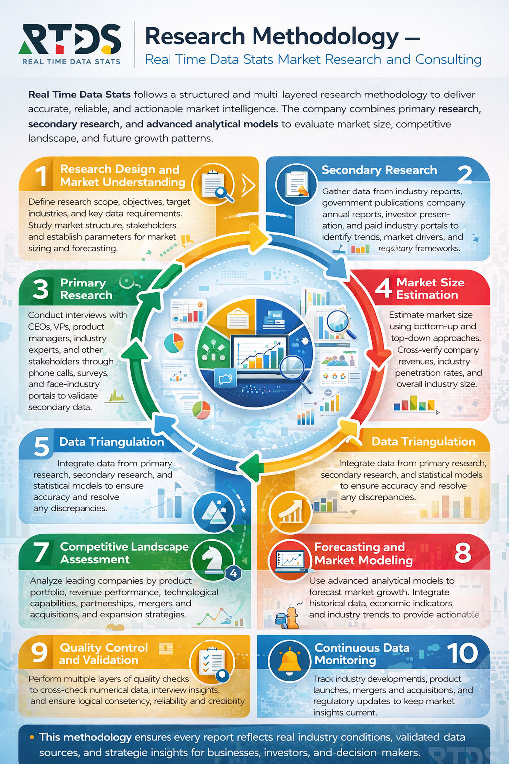
Research Methodology
- Data Collection Methods
- Primary Research
- Secondary Research
- Market Size Estimation Model
- Forecasting Approach
- Data Validation and Triangulation
Market Dynamics
- Market Drivers
- Market Restraints
- Market Opportunities
- Market Challenges
- Emerging Trends
- Regulatory Framework
Landslide Detection Sensor Market Segmentation Analysis
- By Type
- Ground-Based Sensors
- Satellite-Based Sensors
- Wireless Sensor Networks
- GNSS/GPS Sensors
- Inclinometers
- Acoustic Emission Sensors
- By Technology
- Remote Sensing Technology
- IoT-Enabled Monitoring
- LiDAR Technology
- Radar-Based Monitoring
- Fiber Optic Sensing
- Seismic Monitoring Technology
- By Application
- Infrastructure Monitoring
- Mining Area Monitoring
- Transportation Corridor Monitoring
- Dam and Reservoir Monitoring
- Urban Slope Monitoring
- Forest and Mountain Region Monitoring
- By End-User
- Government Agencies
- Construction Companies
- Mining Companies
- Transportation Authorities
- Environmental Monitoring Organizations
- Research Institutions
- By Deployment Mode
- Surface Monitoring Systems
- Subsurface Monitoring Systems
- Aerial Monitoring Systems
- Fixed Monitoring Stations
- Portable Monitoring Systems
- Real-Time Monitoring Systems
- By Component
- Sensors
- Data Loggers
- Communication Modules
- Software Platforms
- Power Supply Units
- Control Units
- By Monitoring Method
- Continuous Monitoring
- Periodic Monitoring
- Early Warning Systems
- Real-Time Data Acquisition
- Predictive Monitoring
- Manual Monitoring Systems
- By Connectivity
- Wired Systems
- Wireless Systems
- Satellite Communication
- Cellular Network-Based
- LoRaWAN-Based
- Cloud-Connected Systems
- By Installation Type
- Permanent Installation
- Temporary Installation
- Embedded Systems
- Surface-Mounted Systems
- Borehole Installation
- Remote Installation
Regional Analysis
- North America
- Europe
- Asia Pacific
- Latin America
- Middle East & Africa
Competitive Landscape
- Market Share Analysis
- Company Benchmarking
- Strategic Developments
- Mergers and Acquisitions
- Partnerships and Collaborations
- Product Launches
Company Profiles
- Company Overview
- Financial Overview
- Product Portfolio
- Strategic Initiatives
- SWOT Analysis
Conclusion
- Market summary
- Key findings
- Strategic insights
Appendix
- Abbreviations
- Glossary of Terms
- Data Sources
- Disclaimer
List of Tables
- Table:1: Global Landslide Detection Sensor Market Size Overview
- Table:2: Market Size by Type
- Table:3: Market Size by Technology
- Table:4: Market Size by Application
- Table:5: Market Size by End-User
- Table:6: Market Size by Deployment Mode
- Table:7: Market Size by Component
- Table:8: Market Size by Monitoring Method
- Table:9: Market Size by Connectivity
- Table:10: Market Size by Installation Type
- Table:11: Regional Market Size Breakdown
- Table:12: North America Market Forecast
- Table:13: Europe Market Forecast
- Table:14: Asia-Pacific Market Forecast
- Table:15: Competitive Landscape Market Share
List of Figures
- Figure:1: Landslide Detection Sensor Market Segmentation Overview
- Figure:2: Market Research Methodology Flowchart
- Figure:3: Market Dynamics Impact Analysis
- Figure:4: Global Market Size Trend Analysis
- Figure:5: Market Share by Type
- Figure:6: Market Share by Technology
- Figure:7: Market Share by Application
- Figure:8: Market Share by End-User
- Figure:9: Market Share by Deployment Mode
- Figure:10: Market Share by Component
- Figure:11: Market Share by Monitoring Method
- Figure:12: Market Share by Connectivity
- Figure:13: Market Share by Installation Type
- Figure:14: Regional Market Distribution
- Figure:15: Competitive Positioning Matrix
Landslide Detection Sensor Market Key Factors
Drivers:
- Governments increase investments in early warning systems.
- Stricter regulations mandate monitoring for infrastructure projects.
- Climate change intensifies rainfall and extreme weather events.
Restraints:
- High installation and maintenance costs limit widespread adoption.
- Complex terrain complicates sensor deployment and data transmission.
- A lack of standardized protocols hinders system interoperability.
Opportunities:
- Advancements in AI and IoT create smarter, predictive analytics platforms.
- Growing public-private partnerships expand monitoring networks.
- Rising urban development in hilly areas boosts demand for slope monitoring.
Challenges:
- Integrating new sensors with existing legacy systems poses technical difficulties.
- High false alarm rates can erode public trust in warning systems.
- Skilled workforce shortages delay installation and data interpretation.
Landslide Detection Sensor Market Key Regional Trends
North America:
- Agencies integrate advanced wireless sensor networks with national hazard maps.
- Demand rises from mining and transportation sectors for operational safety.
- Focus increases on protecting communities from post-wildfire debris flows.
Europe:
- EU-funded projects standardize cross-border monitoring and data sharing.
- Dense sensor networks protect Alpine transport corridors and villages.
- Regulations drive adoption for construction sites in unstable upland areas.
Asia-Pacific:
- Governments rapidly deploy low-cost sensor networks in high-risk regions.
- Major investments target monitoring along new railway and highway routes.
- Communities adopt hybrid systems combining modern sensors and local knowledge.
Latin America:
- Cities implement sensors to mitigate risks in informal hillside settlements.
- Mining companies invest in monitoring to ensure tailings dam safety.
- Countries develop national landslide databases to guide sensor deployment.
Middle East & Africa:
- Infrastructure projects along mountainous corridors incorporate monitoring systems.
- Regional collaboration increases to address rainfall-induced landslide risks.
- Focus begins on safeguarding key access roads and remote communities.
Frequently Asked Questions
Key Questions Answered
- What is the size and growth rate of the market industry?
- What are the main drivers influencing market growth trends?
- What are the key challenges and restraints faced by the market?
- What are the emerging trends and opportunities shaping the market?
- Who are the top players, and what strategies drive their success?
- What are the customer demographics and their buying behaviors?
- What are the key market segments, and what is their scope?
- What are the geographical dynamics, and which region dominates?
- What are the market forecasts and projections for the next decade?
- What regulatory factors are critical to consider for market growth?
Why Choose our Company?
- Major facts and stats backing every report we offer.
- Comprehensive analysis tailored to your business needs.
- Accurate insights backed by extensive market research.
- Expert support to address your queries promptly.
- Data-driven strategies for better decision-making.
- In-depth reports with actionable
recommendations. - Reliable statistics from trusted industry
sources. - Customizable reports to suit your specific goals.
- Unmatched quality and precision in market analysis.
- Competitive pricing with premium content delivery.
Share your experience!
We value you feedback. Please take a moment to review your experience with us.