According to insights from Real Time Data Stats, the Deep-Sea Mineral Survey Market was valued at USD 0.46 billion in 2025. It is expected to grow from USD 0.62 billion in 2026 to USD 4.88 billion by 2033, registering a CAGR of 34% during the forecast period (2026–2033).
MARKET SIZE AND SHARE
The global deep-sea mineral survey market is driven by rising demand for critical metals. Advancements in underwater robotics and sensing technologies are enabling more efficient resource mapping, supporting market growth and increasing commercial interest throughout the forecast period.
Market share will be concentrated among specialized marine survey firms, established offshore service providers, and state-backed consortia. Companies with proprietary exploration technologies and strong offshore expertise will secure dominant positions. Strategic partnerships between mining companies and deep-sea survey specialists will play a key role in winning contracts and shaping competitive dynamics across global players.
INDUSTRY OVERVIEW AND STRATEGY
The deep-sea mineral survey industry involves locating and assessing polymetallic nodules, crusts, and sulphides on the ocean floor. It serves as the critical first link in the nascent seabed mining value chain. The sector is characterized by high technological barriers, significant capital expenditure, and evolving international regulations. Current activity is led by both private entities and national research organizations, all aiming to inventory vast untapped mineral resources essential for the energy transition.
Core strategy for firms focuses on securing exploration licenses from the International Seabed Authority and sponsoring states. Competitive advantage is built through investing in advanced Autonomous Underwater Vehicles, high-resolution sonar systems, and environmental baseline assessment capabilities. Forming strategic alliances with technology developers and potential mining operators is essential to share risk and pool expertise. Success hinges on demonstrating operational efficiency and maintaining strong environmental stewardship credentials to navigate societal and regulatory scrutiny.
REGIONAL TRENDS AND GROWTH
Regional activity is heavily concentrated in specific ocean basins. The Clarion-Clipperton Zone in the Pacific remains the primary focus for polymetallic nodule exploration, driving regional market growth. The Indian Ocean, with its cobalt-rich crusts, and the Mid-Atlantic Ridge for seafloor massive sulphides, are other key hotspots. National programs from countries like China, Japan, South Korea, and India are actively surveying their reserved contract areas, creating strong regional demand for survey services and vessels.
Primary growth drivers include the urgent global demand for battery metals, supportive government funding for strategic resource security, and technological maturation. Key restraints are substantial environmental concerns, uncertain regulatory frameworks, and high operational costs. Major opportunities lie in developing integrated survey-and-assessment packages and new sensor technologies. The foremost challenges involve managing complex stakeholder opposition, ensuring ecological preservation, and achieving commercial viability amidst fluctuating metal prices and potential regulatory delays.
DEEP-SEA MINERAL SURVEY MARKET SEGMENTATION ANALYSIS
BY TYPE:
The polymetallic nodules segment dominates due to rising demand for nickel, cobalt, copper, and manganese used in electric vehicle batteries and renewable energy storage systems. Exploration activity in abyssal plains, particularly in the Clarion-Clipperton Zone, continues to accelerate because these nodules lie exposed on the seabed, reducing overburden complexity. Seafloor massive sulfides and cobalt-rich ferromanganese crusts also attract strong commercial attention as governments prioritize critical mineral security and diversify raw material supply chains away from land-based geopolitical dependencies.
Rare earth element deposits, phosphorite deposits, and gas hydrate deposits gain prominence as technology improves resource detection accuracy in ultra-deepwater zones. Increasing geopolitical competition for strategic minerals strengthens investment in survey programs focused on untapped basins. Environmental scrutiny, however, shapes exploration intensity, compelling operators to integrate high-resolution mapping and baseline ecosystem analysis. The dominant factor across this segment remains the global transition toward clean energy systems, which directly fuels the urgency to locate and quantify deep-sea mineral reserves.
BY TECHNOLOGY:
Autonomous underwater vehicles dominate technological deployment due to their precision navigation, high-resolution seabed imaging, and ability to operate at extreme depths without continuous surface control. Remotely operated vehicles remain critical for targeted sampling and visual inspection, especially in rugged hydrothermal vent regions. Advanced sonar mapping systems and seismic survey technologies further strengthen this segment by enabling accurate sub-surface profiling, which significantly reduces geological uncertainty and enhances mineral resource estimation reliability.
Magnetometers, gravimeters, and subsea sampling equipment support comprehensive geophysical and geochemical assessments, making integrated technology platforms the dominant operational model. Continuous innovation in sensor miniaturization, artificial intelligence–based data analytics, and real-time communication systems improves survey efficiency and lowers operational risk. The primary driving factor in this segment is technological advancement that increases depth capability, mapping accuracy, and operational autonomy, thereby reducing exploration costs while improving data quality in harsh marine environments.
BY SURVEY METHOD:
Bathymetric and seabed mapping surveys dominate early-stage exploration because they establish foundational terrain models necessary for resource targeting. Geophysical and geochemical surveys strengthen deposit validation by identifying mineralization signatures beneath sediment layers. Environmental baseline surveys gain strategic importance as regulators demand comprehensive ecosystem assessments before granting exploration licenses. Resource estimation surveys follow as a critical step to determine economic viability and investment feasibility.
The dominant factor shaping this segment is regulatory compliance combined with technical accuracy. Governments and international authorities require detailed environmental documentation, making environmental baseline surveys indispensable. Simultaneously, investors demand precise reserve quantification before committing capital, elevating the importance of advanced geophysical and geochemical methodologies. Integrated survey approaches that combine mapping, sampling, and impact assessment increasingly define competitive differentiation within the deep-sea mineral survey landscape.
BY APPLICATION:
Mineral exploration represents the largest application segment due to intensifying global competition for battery metals and strategic minerals. Resource assessment follows closely, as verified data on mineral concentration and spatial distribution determines commercial feasibility. Offshore mining planning depends heavily on high-resolution survey outputs to design extraction strategies while minimizing operational risk. Environmental impact assessment applications expand rapidly because ecological preservation has become central to licensing and public acceptance.
Scientific research and government geological surveys also drive steady demand, particularly in regions where national agencies seek to map exclusive economic zones for strategic advantage. The dominant factor in this segment is the global push for energy transition minerals, which compels both private and public entities to accelerate exploration programs. Simultaneously, environmental accountability requirements ensure that impact assessment remains an equally critical application area.
BY END-USER:
Mining companies dominate the end-user landscape as they directly invest in exploration programs to secure long-term mineral supply. Government agencies play a strategic role by funding geological surveys and regulating seabed resource access under international maritime frameworks. Oil and gas companies increasingly diversify into seabed mineral exploration, leveraging offshore operational expertise and subsea infrastructure capabilities.
Research institutions and environmental organizations contribute to baseline ecological studies and impact modeling, particularly in biodiversity-sensitive zones. Defense and maritime authorities also participate due to strategic seabed mapping and geopolitical considerations. The dominant factor across this segment is resource security, as nations and corporations seek stable access to critical minerals essential for advanced manufacturing and renewable energy technologies.
BY WATER DEPTH:
Deep sea and abyssal zone operations dominate due to the concentration of polymetallic nodules and sulfide deposits within these depth ranges. Ultra-deepwater and hadal zone surveys expand gradually as technological capability improves, enabling operations beyond 6,000 meters. Shallow water and continental shelf surveys remain relevant but contribute comparatively lower mineral density for battery-grade metals.
The primary driving factor in this segment is mineral concentration at greater depths combined with technological breakthroughs that reduce operational risk. Advancements in pressure-resistant materials, autonomous navigation, and long-duration battery systems enhance survey viability in extreme depths. Investment patterns increasingly favor deeper zones where high-value critical minerals are concentrated, reinforcing depth capability as a competitive advantage.
BY COMPONENT:
Survey equipment represents the dominant component due to its capital-intensive nature and continuous technological upgrades. Navigation systems and communication systems ensure operational precision and real-time data transfer, especially in remote offshore environments. Data processing software grows rapidly as high-resolution imaging generates massive datasets requiring advanced analytics and modeling tools.
Sampling tools and support vessels complete the operational ecosystem, enabling physical validation of remote sensing data. The dominant factor in this segment is the integration of hardware and software platforms that enhance survey accuracy while reducing downtime. Companies increasingly invest in digital data platforms to improve interpretation speed and deliver actionable geological insights.
BY DEPLOYMENT MODE:
Ship-based surveys remain dominant because surface vessels serve as operational hubs for launching and recovering subsea vehicles. Subsea vehicle-based surveys gain rapid momentum due to their flexibility and ability to operate in confined or rugged terrain. Hybrid deployment systems integrate multiple technologies to maximize coverage and data reliability.
Tethered and untethered systems both hold relevance depending on operational objectives and depth requirements. Satellite-integrated systems improve navigation accuracy and data transmission efficiency. The dominant factor across this segment is operational efficiency, as companies seek deployment models that reduce fuel costs, enhance safety, and optimize data collection in challenging marine conditions.
BY SERVICE TYPE:
Data acquisition services dominate revenue generation because exploration programs require extensive offshore campaigns. Data processing and interpretation services follow closely, driven by increasing complexity of geospatial datasets. Consulting services grow as regulatory frameworks evolve and companies require strategic guidance for compliance and feasibility assessment.
Environmental monitoring and technical support services expand due to ongoing ecosystem observation requirements and equipment maintenance needs. Project management services coordinate multi-stakeholder operations across jurisdictions. The dominant factor in this segment is the shift toward outsourced expertise, allowing mining operators and governments to leverage specialized technological capabilities without maintaining extensive in-house survey infrastructure.
RECENT DEVELOPMENTS
- In Jan 2024: The International Seabed Authority (ISA) resumed critical negotiations in Jamaica on its mining code, a pivotal regulatory framework for future commercial deep-sea mineral exploitation, impacting all survey companies' timelines.
- In Jul 2024: China's COMRA launched a major new survey expedition in the Indian Ocean using its advanced research vessel ""Dayang Yihao,"" focusing on polymetallic sulphide deposits within its contracted exploration area.
- In Nov 2024: The UK-based company Seabed 2030, in partnership with The Metals Company, announced a significant expansion of its nodule resource dataset in the Clarion-Clipperton Zone, upgrading inferred resource estimates.
- In Feb 2025: Terrageos, a marine survey firm, unveiled its new ultra-high-resolution deep-tow seismic system designed specifically for detailed seabed substrate characterization, enhancing pre-collection environmental assessment.
- In Apr 2025: A strategic alliance was formed between Fugro and Norwegian mining startup Loke Marine Minerals to accelerate survey and resource definition for seabed mineral resources on the Norwegian continental shelf.
KEY PLAYERS ANALYSIS
- Fugro
- Ocean Infinity
- The Metals Company (TMC)
- Lockheed Martin (via UK Seabed Resources)
- DEME Group
- China Minmetals Corporation
- Korea Institute of Ocean Science & Technology (KIOST)
- Japan Oil, Gas and Metals National Corporation (JOGMEC)
- Allseas
- Bauer Spezialtiefbau
- Soil Machine Dynamics (SMD)
- i-Tech (Subsea 7)
- Nautilus Minerals (inactive but historically significant)
- GSR (Global Sea Mineral Resources)
- Seabed 2030
- Royal IHC
- Odyssey Marine Exploration
- Neptune Minerals
- DeepGreen (acquired by The Metals Company)
- Nordic Mining
Deep-Sea Mineral Survey Market Segmentation Analysis
By Type:
- Polymetallic Nodules
- Seafloor Massive Sulfides (SMS)
- Cobalt-Rich Ferromanganese Crusts
- Rare Earth Element (REE) Deposits
- Phosphorite Deposits
- Gas Hydrate Deposits
By Technology:
- Autonomous Underwater Vehicles (AUVs)
- Remotely Operated Vehicles (ROVs)
- Seismic Survey Systems
- Sonar Mapping Systems
- Magnetometers & Gravimeters
- Subsea Sampling Equipment
By Survey Method:
- Bathymetric Survey
- Geophysical Survey
- Geochemical Survey
- Environmental Baseline Survey
- Resource Estimation Survey
- Seabed Mapping Survey
By Application:
- Mineral Exploration
- Resource Assessment
- Environmental Impact Assessment
- Offshore Mining Planning
- Scientific Research
- Government Geological Survey
By End-User:
- Mining Companies
- Oil & Gas Companies
- Government Agencies
- Research Institutions
- Environmental Organizations
- Defense & Maritime Authorities
By Water Depth:
- Shallow Water (<200m)
- Continental Shelf (200–1,000m)
- Deep Sea (1,000–4,000m)
- Abyssal Zone (4,000–6,000m)
- Hadal Zone (>6,000m)
- Ultra-Deepwater Operations
By Component:
- Survey Equipment
- Navigation Systems
- Data Processing Software
- Communication Systems
- Sampling Tools
- Support Vessels
By Deployment Mode:
- Ship-Based Surveys
- Subsea Vehicle-Based Surveys
- Hybrid Deployment Systems
- Tethered Systems
- Untethered Systems
- Satellite-Integrated Systems
By Service Type:
- Consulting Services
- Data Acquisition Services
- Data Processing & Interpretation
- Environmental Monitoring Services
- Technical Support & Maintenance
- Project Management Services
By Geography:
- North America (USA, Canada, Mexico)
- Europe (UK, Germany, France, Italy, Spain, Rest of Europe)
- Asia-Pacific (China, Japan, Australia, South Korea, India, Rest of Asia-Pacific)
- South America (Brazil, Argentina, Rest of South America)
- Middle East and Africa (GCC Countries, South Africa, Rest of MEA)
Deep-Sea Mineral Survey Market: Table of Contents
Executive Summary
- Market Snapshot
- Key Findings
- Strategic Insights
- Analyst Recommendations
Introduction
- Market Definition
- Scope of Study
- Research Objectives
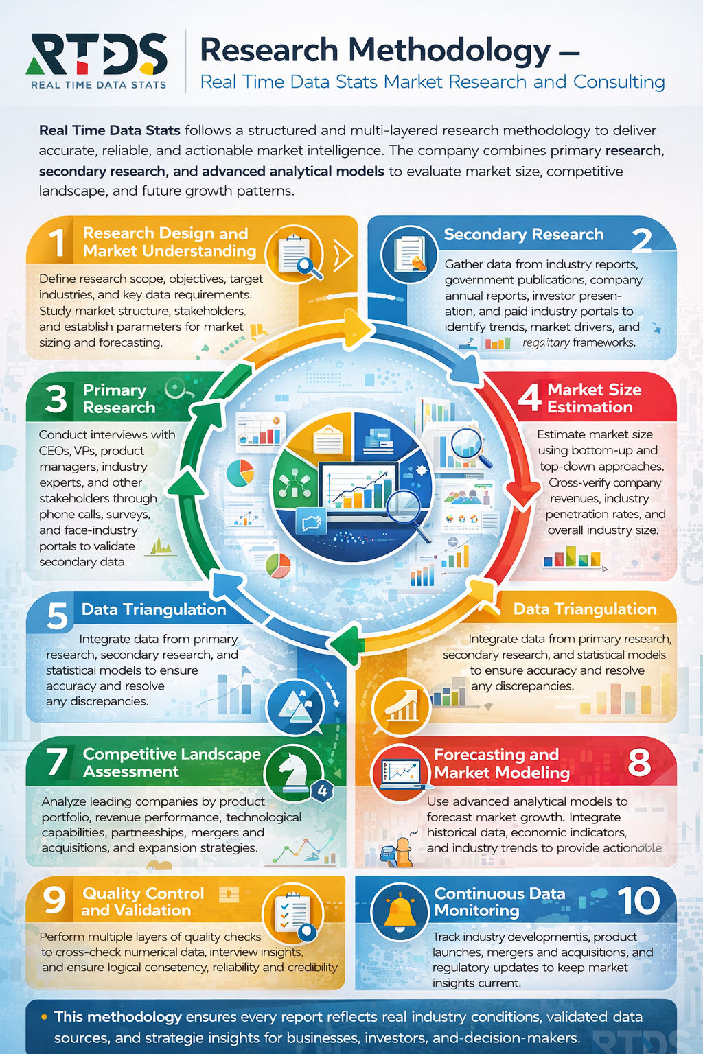
- Research Methodology
- Assumptions & Limitations
Market Overview
- Industry Evolution
- Value Chain Analysis
- Supply Chain Assessment
- Regulatory Landscape
- Environmental & Sustainability Framework
- Investment Landscape
- Technological Advancements
Market Dynamics
- Drivers
- Restraints
- Opportunities
- Challenges
Deep-Sea Mineral Survey Market Segmentation Analysis
- By Type
- Polymetallic Nodules
- Seafloor Massive Sulfides (SMS)
- Cobalt-Rich Ferromanganese Crusts
- Rare Earth Element (REE) Deposits
- Phosphorite Deposits
- Gas Hydrate Deposits
- By Technology
- Autonomous Underwater Vehicles (AUVs)
- Remotely Operated Vehicles (ROVs)
- Seismic Survey Systems
- Sonar Mapping Systems
- Magnetometers & Gravimeters
- Subsea Sampling Equipment
- By Survey Method
- Bathymetric Survey
- Geophysical Survey
- Geochemical Survey
- Environmental Baseline Survey
- Resource Estimation Survey
- Seabed Mapping Survey
- By Application
- Mineral Exploration
- Resource Assessment
- Environmental Impact Assessment
- Offshore Mining Planning
- Scientific Research
- Government Geological Survey
- By End-User
- Mining Companies
- Oil & Gas Companies
- Government Agencies
- Research Institutions
- Environmental Organizations
- Defense & Maritime Authorities
- By Water Depth
- Shallow Water (<200m)
- Continental Shelf (200–1,000m)
- Deep Sea (1,000–4,000m)
- Abyssal Zone (4,000–6,000m)
- Hadal Zone (>6,000m)
- Ultra-Deepwater Operations
- By Component
- Survey Equipment
- Navigation Systems
- Data Processing Software
- Communication Systems
- Sampling Tools
- Support Vessels
- By Deployment Mode
- Ship-Based Surveys
- Subsea Vehicle-Based Surveys
- Hybrid Deployment Systems
- Tethered Systems
- Untethered Systems
- Satellite-Integrated Systems
- By Service Type
- Consulting Services
- Data Acquisition Services
- Data Processing & Interpretation
- Environmental Monitoring Services
- Technical Support & Maintenance
- Project Management Services
Regional Analysis
- North America
- Europe
- Asia Pacific
- Latin America
- Middle East & Africa
Competitive Landscape
- Market Share Analysis
- Company Benchmarking
- Strategic Developments
- Mergers & Acquisitions
- Partnerships & Collaborations
- Product Launches
- Investment & Expansion Plans
Company Profiles
- Overview
- Financial Performance
- Product Portfolio
- Recent Developments
- SWOT Analysis
Conclusion
- Market summary
- Key findings
- Strategic insights
Appendix
- Abbreviations
- Glossary of Terms
- List of Data Sources
- Disclaimer
List of Tables
- Table:1: Global Market Size by Value
- Table:2: Global Market Size by Volume
- Table:3: Market Share by Type
- Table:4: Market Share by Technology
- Table:5: Market Share by Survey Method
- Table:6: Market Share by Application
- Table:7: Market Share by End-User
- Table:8: Market Share by Water Depth
- Table:9: Market Share by Component
- Table:10: Market Share by Deployment Mode
- Table:11: Market Share by Service Type
- Table:12: Regional Market Size Overview
- Table:13: Competitive Market Share Analysis
- Table:14: Investment & Funding Analysis
- Table:15: Regulatory Framework by Region
List of Figures
- Figure:1: Deep-Sea Mineral Survey Market Value Chain
- Figure:2: Market Dynamics Framework
- Figure:3: Global Market Growth Trend
- Figure:4: Market Segmentation Overview
- Figure:5: Revenue Share by Type
- Figure:6: Revenue Share by Technology
- Figure:7: Revenue Share by Survey Method
- Figure:8: Revenue Share by Application
- Figure:9: Revenue Share by End-User
- Figure:10: Revenue Share by Water Depth
- Figure:11: Revenue Share by Component
- Figure:12: Revenue Share by Deployment Mode
- Figure:13: Revenue Share by Service Type
- Figure:14: Regional Revenue Distribution
- Figure:15: Competitive Positioning Matrix
Deep-Sea Mineral Survey Market Key Factors
Drivers:
- Rising demand for critical metals accelerates exploration activities.
- Technological advancements improve survey efficiency and data precision.
- Governments and private entities increase strategic investments.
Restraints:
- Incomplete regulatory frameworks create uncertainty for operators.
- Extremely high operational costs limit market entry.
- Environmental concerns prompt calls for strict oversight.
Opportunities:
- Developing nations seek partnerships to build survey capabilities.
- New sensor and AUV technologies open untapped survey areas.
- Recycling and battery industries expand potential client base.
Challenges:
- Significant technological gaps remain for sustainable extraction.
- International seabed authority permits progress slowly.
- Public opposition and activism influence project timelines.
Deep-Sea Mineral Survey Market Key Regional Trends
North America:
- Public and private funding focuses on strategic mineral supply chains.
- Companies lead in developing advanced robotics and sensing platforms.
- Regulatory bodies emphasize robust environmental impact assessments.
Europe:
- Strong public debate balances economic potential against ecological risks.
- EU initiatives fund research for less invasive survey technologies.
- Nations actively shape international seabed mining regulations.
Asia-Pacific:
- China, Japan, and South Korea secure exploration contracts in international waters.
- Investments target polymetallic nodules and rare-earth element deposits.
- Regional collaboration grows to develop deep-sea survey expertise.
Rest of the World:
- Pacific Island nations assess potential economic benefits and risks.
- International partnerships help build regional survey capacity.
- Countries with EEZ resources evaluate licensing frameworks.
Frequently Asked Questions
Key Questions Answered
- What is the size and growth rate of the market industry?
- What are the main drivers influencing market growth trends?
- What are the key challenges and restraints faced by the market?
- What are the emerging trends and opportunities shaping the market?
- Who are the top players, and what strategies drive their success?
- What are the customer demographics and their buying behaviors?
- What are the key market segments, and what is their scope?
- What are the geographical dynamics, and which region dominates?
- What are the market forecasts and projections for the next decade?
- What regulatory factors are critical to consider for market growth?
Why Choose our Company?
- Major facts and stats backing every report we offer.
- Comprehensive analysis tailored to your business needs.
- Accurate insights backed by extensive market research.
- Expert support to address your queries promptly.
- Data-driven strategies for better decision-making.
- In-depth reports with actionable
recommendations. - Reliable statistics from trusted industry
sources. - Customizable reports to suit your specific goals.
- Unmatched quality and precision in market analysis.
- Competitive pricing with premium content delivery.
Share your experience!
We value you feedback. Please take a moment to review your experience with us.